A hurricane forecast that is “a day better” sounds like marketing until you ask what that phrase actually means. Google DeepMind‘s WeatherNext Cyclones deserves the question, because the underlying result is more interesting than the slogan.
The model does not simply spot storms one day before everyone else. Instead, it can often reach a given level of forecast accuracy at a longer lead time than leading operational models. In the Nature paper, the system predicts tropical-cyclone track, intensity, and wind structure with ensemble forecasts extending to 15 days. Across tests on cyclones from 2023 to 2025, the researchers report an average lead-time advantage of about a day or more over strong baselines.
That makes this more than another flashy Google AI weather forecast. It attacks a stubborn forecasting trade-off: global models are good at steering tracks, while high-resolution regional models are better at storm intensity. WeatherNext tries to do both in one probabilistic system, then expose the uncertainty instead of pretending there is one inevitable future.
Table of Contents
1. What Is WeatherNext Cyclones, And How Is It Different From WeatherNext 2?
WeatherNext Cyclones, or WN-C, is a global AI weather model specialized for tropical cyclones. It predicts the surrounding atmosphere and cyclone-specific variables together, including position, maximum sustained wind, minimum sea-level pressure, radius of maximum wind, and wind radii for several thresholds. The model runs autoregressively in six-hour steps out to 15 days.
It is also probabilistic. Rather than outputting one neat line on a map and calling it destiny, it can generate many plausible futures. The paper evaluated 50-member or larger ensembles, while Google says the system has now been scaled to 1,000 scenarios for operational exploration.
WeatherNext Cyclones: Key Features, Forecast Capabilities and Model Details
The naming is messy enough to trip up careful readers. The repository says WeatherNext 2 and WN-C use the same cyclone forecasting algorithm but different weights because they were trained independently. The 2025 cyclone checkpoint was also known operationally as FNV3, while the NHC’s postprocessed version was called GDMI.
2. How Accurate Is WeatherNext Cyclones?
There is no useful single percentage called WeatherNext accuracy. Accuracy depends on what is being predicted, at what lead time, for which storm, and with which metric. The paper therefore compares track error, intensity error, probabilistic scores, wind radii, calibration, and rapid-intensification performance separately.
The headline numbers are strong.
WeatherNext Cyclones Accuracy: Track, Intensity and Forecast Benchmarks
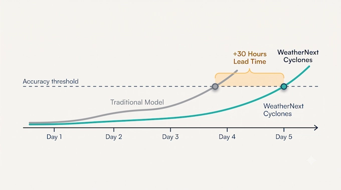
At five days, WeatherNext’s ensemble-mean track error was about 230 km, compared with 370 km for ECMWF ENS and 335 km for GenCast. ENS only reached roughly the same 230 km error level at about 3.75 days, which translates to just over 30 hours of equivalent track skill.
Intensity is the more surprising result. A global AI model is not supposed to have an easy time with the compact physics around a cyclone core. Yet WN-C’s three-day mean intensity forecast was 3.75 knots more accurate than HAFS in the homogeneous comparison, and its 34-knot wind-radius errors were lower than both ENS and HAFS.
3. What Does “A Day Earlier” Actually Mean?
The phrase does not mean every other model discovers a hurricane on Tuesday while Google’s model discovers it on Monday.
It means forecast skill can be shifted farther into the future. If one system needs to be 3.75 days from an event to reach a certain track error, while WeatherNext reaches that same error five days out, the useful gain is roughly 30 hours. That is a more precise way to understand Google’s “extra day” claim.
Why does that matter if hurricane warnings already exist days in advance? Because operational decisions are not binary. Evacuation planning, port closures, aircraft repositioning, utility crews, hospital staffing, shipping routes, and emergency supplies all become easier when confidence improves earlier. An extra day of equally reliable guidance is more valuable than an extra day of noisy speculation.
4. How Can A Coarse AI Model Forecast Hurricane Intensity So Well?
This is the scientifically awkward part, in a good way.
Traditional forecasting has treated track and intensity as problems living at different scales. Large atmospheric steering currents can be modeled globally, but the storm core contains fine thermodynamic processes that usually reward very high resolution. The paper explicitly frames this as a longstanding scale dilemma.
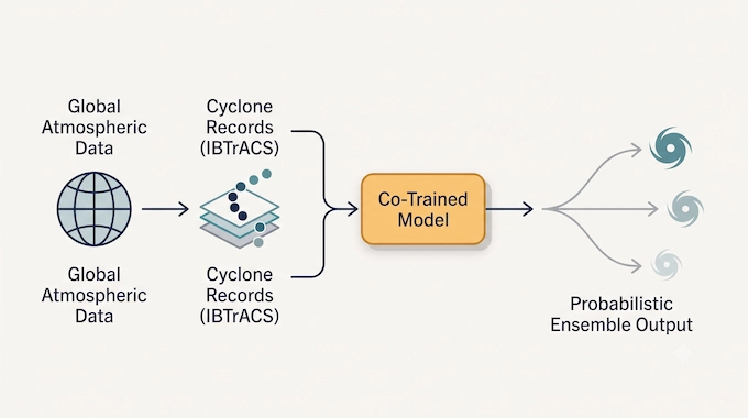
WN-C attacks it with co-training. The model learns from decades of global ECMWF atmospheric analysis while also receiving explicit cyclone targets from IBTrACS, an expert-curated database containing nearly 5,000 historical storms. That means the network is not asked to infer cyclone intensity only from a coarse weather grid. It is trained directly on cyclone location, intensity, and wind structure as part of the same prediction problem.
The second trick is the probabilistic architecture. WeatherNext uses Functional Generative Networks, or FGNs, to produce diverse but coherent forecast trajectories. The paper reports that FGN needs one neural-network call per forecast step and is about eight times faster at inference than the diffusion-based GenCast approach.
Google says a 15-day forecast can be generated in under a minute on a TPU, which makes very large ensembles practical. Those 1,000-member ensembles matter most for low-probability, high-impact outcomes, where 50 samples may simply not explore enough of the tail.
The provocative result is that the main model works from roughly 0.25-degree, about 28 km, atmospheric inputs. The researchers argue this shows ultra-high-resolution input is not a strict prerequisite for state-of-the-art intensity forecasting. It does not prove fine-scale physics are unimportant. It suggests the coarse atmospheric state contains more usable information about intensity than forecasters and modelers previously assumed.
5. WeatherNext Vs ECMWF, HAFS, GenCast, And The NHC
The cleanest comparison depends on the task.
- WeatherNext vs ECMWF ENS: the strongest story is track forecasting. WN-C’s ensemble mean had lower track errors across lead times in the paper’s evaluation.
- WeatherNext vs HAFS: this is mainly an intensity and structure comparison. HAFS is a specialized high-resolution regional hurricane model. WN-C’s intensity error was lower across the evaluated horizons, with statistically significant gains from 0.5 to 3.25 days.
- WeatherNext vs GenCast: both are AI weather systems, but GenCast was not trained with the same cyclone-specific targets. The paper even debiased GenCast’s systematically low intensity forecasts before comparison, giving it a stronger baseline.
- WeatherNext vs the NHC: this comparison is often framed incorrectly. The National Hurricane Center is not one model. Human forecasters integrate observations, model guidance, consensus systems, storm history, and operational expertise.
In fact, the paper’s most practical result may be what happens when WeatherNext is added to existing guidance. A simulated weighted blend with the NHC’s track consensus improved track error by about 18% to 38% depending on lead time, averaging 28%. Intensity consensus gains were smaller, averaging 6%.
That is a better story than “AI beats meteorologists.” A model with strong skill and somewhat different failure modes can make the whole forecasting stack better.
6. Can It Predict Cyclones Before Formation And Rapid Intensification?
Yes, WN-C attempts cyclogenesis, not just tracking storms that already exist. The evaluation includes paired tests for formed cyclones and unpaired tests that also assess the formation and evolution of new systems.
But strong track skill after formation should not be mistaken for perfect genesis forecasting. The tracker uses thresholds to identify candidate formations and discards predicted genesis tracks lasting 2.5 days or less to suppress short-lived, implausible detections.
Rapid intensification is harder still. Google highlighted Hurricane Melissa in 2025 as a real-world case where the model helped anticipate rapid strengthening and landfall in Jamaica. The paper, however, is more restrained. No single model dominated every precision-recall trade-off for rapid intensification. WN-C was competitive or better across a range of thresholds and raised the reported Critical Success Index from below 0.3 to about 0.5.
So no, sudden strengthening is not “solved.” The model is better evidence that AI hurricane models are becoming useful probabilistic guidance for a notoriously difficult event class.
7. Where The Model Still Gets Things Wrong
The paper is unusually helpful here because it exposes engineering compromises rather than pretending the forecast pipeline is magical.
- First, intensity ensembles are still somewhat under-spread. In plain English, the model can sometimes express a narrower range of possibilities than the true uncertainty warrants, even though its calibration is substantially better than the probabilistic baselines.
- Second, the cyclone tracker has failure modes. Nearby systems can, in principle, cause a track to jump from one cyclone to another. The researchers observed a merging failure where two tracks could collapse onto the same storm and added a pruning step to reduce it. In tracker validation, jumps were rare, around 1% of cases.
- Third, there is operational latency. Like other analysis-dependent systems, WN-C forecasts arrive about 6.5 hours after the nominal synoptic time. The study adjusted paired evaluations to reflect that reality rather than comparing an unrealistically fresh AI forecast with operational guidance.
- Finally, the test window is still finite. The main evaluation covers recent seasons, with 2022 used for validation and later years held out for testing. That is meaningful evidence, but it does not settle every basin, every unusual storm regime, or long-term climate distribution shift. Those are reasons for continued verification, not reasons to dismiss the current results.
8. Are Meteorologists Actually Using It?
The system is not a lab-only demo. The paper says real-time forecasts have been published on Google Weather Lab cyclones since June 2025, and Google’s launch material describes collaboration with the NHC, CIRA, the UK Met Office, and other weather agencies.
Its realistic near-term role is not replacing the forecaster. It is becoming another unusually useful source of guidance.
That distinction matters. Forecast centers already rely on multiple models because disagreement contains information. WeatherNext’s errors are not perfectly correlated with traditional numerical weather prediction systems, which is exactly why adding it to consensus guidance can improve the final forecast. A forecaster does not need the AI model to be infallible. They need it to be skillful, calibrated, fast, and usefully different.
9. How To Use WeatherNext, The API, And Open-Source Models
For most people, the easiest route is Weather Lab. It lets you inspect current cyclone tracks and broader WeatherNext fields such as wind, precipitation, and temperature without running the model yourself.
Developers have several other routes. The official repository points to Google Cloud feeds, including Earth Engine, BigQuery, and Vertex AI, plus Open-Meteo for an API and interactive builder. So if you are searching for a simple WeatherNext API, the practical route is usually hosted forecast data rather than self-hosting the neural network.
For researchers who want WeatherNext open source access, Google has released code, pretrained weights, and a Colab workflow. The repository includes a 1-degree Cyclones Mini model designed for lower memory and compute. The Colab defaults to the Mini model on a v5e-1 TPU. Full non-Mini models need substantially stronger hardware, with the repository naming v5p TPU or H100-class GPU resources.
One warning for builders: this is research code, not a stable consumer SDK. The repository explicitly says API stability is not guaranteed and advises pinning a release. It also states that WeatherNext outputs do not replace official meteorological alerts or warnings.
10. Is WeatherNext Cyclones A Real Breakthrough Or Just Better AI Hype?
The evidence supports the word “breakthrough” more than the usual launch-day AI story, but only if we keep the claim narrow.
WN-C shows substantial gains in track forecasting, unexpectedly strong intensity results, useful wind-structure predictions, better probabilistic guidance, and enough inference efficiency to make 1,000-member ensembles practical. It has also moved beyond retrospective benchmarks into live forecasting workflows.
What it has not done is remove hurricane uncertainty, solve rapid intensification, guarantee correct cyclogenesis, or make official forecasters obsolete. That would be the wrong lesson.
The more useful takeaway is that AI weather prediction is starting to cross an important line. It is no longer only matching broad atmospheric fields quickly. It is becoming good enough at specialized, operationally difficult tasks to improve the ensemble of tools humans already trust.
For developers and researchers, the next step is straightforward: inspect the live forecasts, test the open models, and compare their outputs against the operational guidance you already use. For everyone else, keep the hierarchy clear. Explore WeatherNext Cyclones for insight, but follow your national meteorological agency for actual warnings.
Binary Verse AI will keep tracking how systems like WeatherNext move from benchmark wins into real operational use. If you want the technical story after the launch headline, follow Binary Verse AI for model breakdowns, benchmark analysis, and practical AI research coverage.
What Is WeatherNext 2, and How Is It Different From WeatherNext Cyclones?
WeatherNext 2 and WeatherNext Cyclones are closely related AI weather models from Google DeepMind’s WeatherNext family. Both can forecast tropical cyclones using the same underlying cyclone-prediction approach, but they were trained separately with different model weights. WeatherNext Cyclones specifically refers to the cyclone-focused model checkpoints evaluated in the Nature study, while WeatherNext 2 is the newer broader weather model that also predicts additional atmospheric variables, including 100-meter wind.
WeatherNext Cyclones predicts storm track, intensity, wind structure, and uncertainty while simultaneously modeling the surrounding atmosphere. Readers interested in Google’s newer general-purpose forecasting system can also see our separate WeatherNext 2 guide.
How Accurate Is WeatherNext 2 for Hurricane Forecasting?
There is no single percentage that represents WeatherNext accuracy for hurricanes. Performance changes depending on whether you measure cyclone track, intensity, wind structure, probability calibration, or forecast lead time.
In the WeatherNext Cyclones study, the five-day mean track error was about 230 km, compared with 370 km for ECMWF ENS and 335 km for GenCast. Its three-day intensity forecast was also 3.75 knots more accurate than NOAA HAFS, while probabilistic intensity error measured by CRPS was reduced by more than 50% at many lead times compared with ENS and GenCast.
These results are better understood as task-specific benchmark gains rather than a claim that the model is “X% accurate” at predicting hurricanes.
How Do I Access WeatherNext 2?
You can access WeatherNext 2 forecasts in several ways depending on what you want to do. For simply viewing forecasts, Google Weather Lab provides an interactive interface that includes cyclone tracks and broader weather predictions. Developers can access forecast data through Google Cloud services such as BigQuery, Earth Engine, and Vertex AI, while Open-Meteo provides an API and interactive forecast builder.
Google also provides the WeatherNext source code, pretrained model weights, documentation, and research notebooks for users who want to experiment with the models directly.
How Do I Use WeatherNext 2?
The easiest way to use WeatherNext 2 depends on your technical needs:
General users: Use Google Weather Lab to explore cyclone tracks, wind, precipitation, temperature, and forecast uncertainty visually.
Developers: Use hosted WeatherNext forecast feeds through Google Cloud or the Open-Meteo WeatherNext API rather than running the neural network yourself.
Researchers and ML engineers: Use Google DeepMind’s GitHub repository, pretrained weights, and official Colab notebook to run and analyze the models directly.
The official Colab workflow defaults to the lightweight WeatherNext Cyclones Mini model, while the larger models require considerably stronger TPU or GPU hardware.
Which AI Is Best for Weather Forecasting?
There is no single best AI weather forecasting model for every task. Different systems specialize in different forecast variables, horizons, resolutions, and uncertainty estimates.
WeatherNext Cyclones is particularly notable for tropical cyclone track, intensity, wind structure, and probabilistic forecasting. In the published evaluation, it outperformed ECMWF ENS on cyclone track and NOAA HAFS on several intensity and wind-radius comparisons. Other AI weather models, including GenCast, GraphCast, and WeatherNext 2, target broader global weather forecasting objectives and may be more appropriate for different applications.
For cyclone forecasting specifically, the strongest evidence currently supports treating WeatherNext as an additional high-skill forecasting tool, not as a universal replacement for operational models or human meteorologists.