Introduction
You can stare at a map for hours and miss the one insight that changes everything. Or you can ask a clear question and get a crisp answer. That is the promise of geospatial AI inside Google Earth. It turns the planet into a conversation, not a slideshow. You type a question. The system reads it, finds the right data, runs the analysis, and gives you a map, a table, and the “so what” in minutes.
Table of Contents
1. What Is Geospatial AI? A Leap Beyond Traditional Mapping
Traditional mapping stacks images and layers, then leaves the thinking to you. Geospatial AI adds reasoning. It uses models that understand imagery, weather, terrain, infrastructure, and population signals, then connects them to answer real questions. Think of it as a planetary analyst that never sleeps. It can spot algae in river imagery, estimate which neighborhoods sit below a storm surge line, or compare distant mangrove forests by their physical signatures.
Here is the important shift. In geospatial AI the unit of work is a question. “Where are storm drains within 50 meters of public schools in Red Hook.” “Which Florida rivers show harmful algae this month.” “Which counties on the Gulf Coast combine high population density with low elevation along a projected hurricane path.” The models break these into steps, search for the right datasets, run spatial joins, and return a result you can explain to a city planner or a water manager.
To see the contrast with classical GIS, imagine doing the same analysis by hand. You would hunt for layers, fix projections, buffer points, and compute intersections. You would cross reference results in spreadsheets. Geospatial AI collapses that workflow into a single, auditable exchange. You keep your attention on the question and the explanation, not the plumbing. That is why geospatial AI is not a toy, it is a practical shift in how teams work with place based data.
Geospatial tasks also benefit from scale. Storm tracks, crop stress, urban heat islands, and migration patterns do not respect county lines. Geospatial AI scales across regions without changing your process. The same question that works in Brooklyn can run across the Gulf Coast, or across the entire United States, and it still returns a clear, defensible answer.
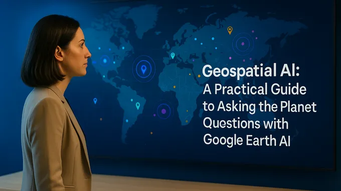
2. Your New Interface To The Planet: Introducing “Ask Google Earth”
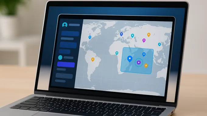
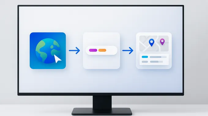
Ask Google Earth is the new chat surface inside Google Earth that brings geospatial AI to your browser. It is powered by Gemini, and it sits directly in the map canvas where the answers belong. You type a request, the agent plans the work, calls imagery, population, and environment models, and responds with a layered map and an auto generated table you can export.
The big win is access. For years, this level of analysis lived in specialized GIS tools with steep learning curves. Ask Google Earth lowers the barrier. Analysts, emergency managers, and students can work with serious spatial questions without hunting for shapefiles or writing projection code. It is the first step in making high quality analysis routine for teams that do not have GIS experts on call. Ask Google Earth sits inside Google Earth AI for a reason. The results appear exactly where you need them, over the scene you are studying. That shortens the loop between a question and a decision.
3. How To Use Google Earth AI: A Step By Step Tutorial
You do not need a manual. You need a working path that gets results on your first try. Use this sequence.
3.1 Open Google Earth On The Web
Go to earth.google.com/web on a desktop browser. Sign in so your work saves.
3.2 Create A New Project
Start a Project so results can land on a map you control. Projects keep your layers, tables, and notes together.
3.3 Activate Ask Google Earth
Find the spark icon labeled Ask Google Earth in the toolbar. Click it to open the chat panel.
3.4 Ask A Specific, Verifiable Question
Try this Red Hook, Brooklyn example, since it shows how the system composes data.
“Map all storm drains located within 50 meters of public schools in Red Hook, Brooklyn. Create a table that lists each school and counts the drains within that distance. Add the schools and the drains as separate layers on the map.”
You should see yellow pins for schools and blue pins for drains inside the buffer, along with a table you can download. This is geospatial AI doing real work, not a demo reel.
3.5 Tune, Iterate, Share
Good prompts read like field instructions. Name the area, the objects, the distances, and the output you want. You can follow up with “color code by risk,” “filter to middle schools,” or “export GeoJSON.” Share the Project with teammates. Decisions move faster when the map explains itself. Because the interface is conversational, new team members learn quickly. You can teach them how to use Google Earth AI in an afternoon.
3.6 Troubleshooting And Tips
If the chat returns something that looks off, be specific about what to fix. “Limit to the last 14 days.” “Use county boundaries, not zip codes.” “Recalculate the buffer at 25 meters.” The agent will adjust and rerun. When a boundary or asset name is ambiguous, draw a polygon or paste a latitude and longitude. When you need to brief a room, ask for a legend and a clear title on the layer.
If your analysis depends on external data, state the source you expect. You can say, “use Data Commons for population” or “use the public flood layer.” That level of clarity makes geospatial AI more predictable for critical work. When you get a result you trust, save the Project, export the table, and capture the exact prompt. A repeatable trail is part of professional geospatial AI practice.
Teams that work in regulated settings have extra needs. Add a review step that checks sources, projections, and spatial joins. Keep sample outputs for each template prompt, then compare new runs to those baselines. This habit turns geospatial AI into a dependable tool rather than a one off experiment.
4. Five Powerful Example Queries To Unlock The Power Of Geospatial AI
Use cases multiply once you see the pattern. Here are five that teams are already running, along with the kind of outputs you can expect.
- Urban Planning And Risk. “Map storm drains within 50 meters of public schools in Red Hook, Brooklyn, then rank schools by count.” Output, a heat colored layer and a table with counts per school.
- Environmental Monitoring. “Find and map harmful algae blooms in Florida rivers from the past 30 days.” Output, polygons over suspected bloom areas plus a timeline of detections. This is environmental monitoring AI with practical bite.
- Disaster Preparedness. “Given a projected hurricane path on the Gulf Coast, show the counties with the highest population density and lowest elevation.” Output, a ranked list with an overlay that highlights the vulnerable corridor. This is AI for disaster response in action.
- Infrastructure Management. “Identify areas where vegetation encroaches on major power lines in Northern California.” Output, a line layer with risk segments and a maintenance report draft.
- Scientific Comparison. “Show global mangrove forests similar to the Mekong Delta in Vietnam.” Output, a map of candidate regions with similarity scores and links to source imagery.
4.1 Table, Query Patterns And Outputs
| Use Case | Example Prompt | Data Combined | Output |
|---|---|---|---|
| Urban Risk | Storm drains near schools in Red Hook | City assets, public schools, elevation | Ranked table, buffer layer |
| Monitoring | Harmful algae blooms in Florida rivers | Recent satellite scenes, water indexes | Polygons, detection timeline |
| Preparedness | Density plus low elevation in hurricane path | Forecast cones, elevation, census density | Ranked counties, corridor overlay |
| Power Lines | Vegetation encroachment on lines | Transmission lines, vegetation indices | Risk segments, maintenance CSV |
| Mangroves | Similar mangroves to Mekong Delta | Global mangrove mask, morphology | Similarity map, scores |
These are not toy prompts. They are geospatial data examples you can adapt to your city, utility, or watershed.
5. The Engine Room, How Gemini Powered Geospatial Reasoning Works
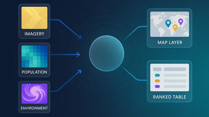
When you type a question, the system does not guess. It plans. The agent reads your request, breaks it into steps, and decides which Earth AI models and datasets fit the job. That orchestration is called Geospatial Reasoning. It fuses three families of capability.
First, imagery models. They understand satellite scenes, detect objects like flooded roads or algae patches, and classify land cover. Second, population models. They learn patterns in human activity, density, and movement, then provide embeddings that help target vulnerable communities at finer resolution. Third, environment models. They forecast weather, floods, air quality, and cyclones, and they do it quickly enough to support time sensitive planning.
The agent chains those parts together. It can call a forecast model for wind probabilities, pull county boundaries, intersect the two, then search for hospitals and shelters inside the highest risk cells. It can upsample from county statistics to zip code estimates using population embeddings, then produce a table that a mayor can read before a storm. The orchestrator approach has another advantage, reproducibility. When an answer drives a budget or a safety plan, you can rerun the chain with the same inputs and get the same outputs. That matters in courtrooms and after action reviews. It also builds trust inside organizations that want to expand their use of geospatial AI without slowing down.
There is another useful behavior. The agent explains its steps. When it chooses a dataset or filter, it records the decision so you can audit the path. That transparency matters when work touches budgets, safety, or legal review.
6. Availability And Pricing, Who Can Use Google Earth AI Right Now
Access is expanding, and it is tiered so teams can start small and grow into heavier use.
6.1 Table, Access Tiers At A Glance
| Plan | Who It Is For | Ask Google Earth Chat | Models And Limits | Notes |
|---|---|---|---|---|
| Standard | Individuals and small teams in the US | Included on the web | Core chat with daily limits | Good for learning and pilots |
| Google AI Pro And Ultra | Power users in the US | Included, higher limits | More runs per day | Best for analysts who need volume |
| Earth Professional | Professional users | Rolling out | Added Earth AI models in chat | Designed for heavier projects |
| Earth Professional Advanced | Professional teams | Rolling out | More datasets, higher caps | Suited to large projects |
| Trusted Tester And Cloud | Enterprises and nonprofits | Invite based | Direct access to Imagery, Population, Environment models | Combine with your data in Google Cloud |
You can do meaningful work in the Standard plan, then step up when the limits start blocking team workflows.
7. Practical Craft, How To Write Questions That Land Useful Answers
Good prompts look like field notes, not poetry. They include three parts. The scope, the measurement, and the output.
Scope names the place and time. “Red Hook, Brooklyn, last 30 days.” Measurement names what to find and how to relate it. “Storm drains within 50 meters of public schools.” Output states how you want to see it. “Point layers for schools and drains, a table with counts per school, and GeoJSON export.”
A few reliable tactics improve results. Be concrete about distance and time windows. Use unambiguous place names or draw a polygon. Ask for tables when you need an audit trail. Ask for map layers when you need to brief a room. If accuracy matters, ask the agent to cite data sources in the response panel so you can verify them.
Prompts improve with practice. Start with a narrow request, verify the output, then widen the scope. “Map schools and drains in Red Hook” becomes “map schools and drains in all five boroughs” only after the first result looks right. This staged approach keeps quality high while you scale. Over time, your team builds a library of patterns that make geospatial AI feel like second nature.
8. Responsible Use, Privacy, Dual Use, And Guardrails
The same power that helps a relief worker can help a bad actor. That is the hard truth about any capable system. The right response is responsible design and thoughtful policy, not fear. Teams working with geospatial AI should be clear about data sensitivity, access control, and review procedures before they push a button.
Work in public interest often uses public imagery, published boundaries, and anonymized population statistics. Keep it that way by default. If you bring private data, restrict access to the smallest group that needs it. Keep an audit log of queries and outputs. If a request feels misaligned with your mission, escalate it before you act.
There is a second guardrail, explainability. When the agent lists its steps and sources, human reviewers can detect mistakes or bias. That makes the work defensible in planning meetings and after action reviews. Ethical use is not an afterthought in geospatial AI. It is a daily practice.
9. Where This Goes Next, From Static Map To Ongoing Conversation
Maps used to be posters for a wall. Then they became slippy tiles in a browser. With geospatial AI they become collaborators. You ask, they answer, and you move. City planners map drains and school routes before the next flood season. Utilities prioritize tree trimming along transmission lines before the wind picks up. Public health teams watch water quality before supplies turn unsafe. Astronomers, farmers, and logistics managers do their versions of the same loop.
The core idea is simple. The world throws signals at us faster than people can parse on their own. Geospatial AI gives us a way to keep pace. It turns satellite scenes, forecasts, and population statistics into decisions that help real places, on real timelines. The work is not abstract. It is a new habit, ask a better question and get a better map.
Call to action. Open Google Earth on the web. Start a Project. Click Ask Google Earth. Run the Red Hook example. Then swap in your city, your watershed, or your grid. If your team could make better decisions with faster, clearer spatial answers, now you know how to use Google Earth AI to get them.
1) What is “Ask Google Earth” and how can I start using it right now?
Ask Google Earth is a chat interface inside Google Earth that lets you run geospatial AI analyses in natural language. On desktop, open earth.google.com, create a Project, click the spark icon, then ask a task focused question. US users can access the chat now, with higher limits for Google AI Pro and Ultra subscribers.
2) What is Geospatial Reasoning, and how is it different from just using Google Earth?
Geospatial Reasoning is a Gemini powered agent that plans multi step analyses. It combines models for imagery, population, and environment, then fuses results into a single answer. Classic Google Earth shows layers, this agent explains relationships and returns maps plus tables you can act on.
3) What are the most powerful real world use cases for Google Earth AI?
High impact uses include disaster response, urban planning, and environmental monitoring. You can rank vulnerable counties along a hurricane path, detect harmful algae blooms from satellite imagery, or flag vegetation encroachment on power lines to prevent outages.
4) Is Google Earth AI available to everyone, and what does it cost?
Access is expanding in tiers. Ask Google Earth is on the web for US users. Google AI Pro and Ultra get higher limits. Professional and Professional Advanced plans are rolling out with added models and data layers, while some capabilities are available to trusted testers and on Google Cloud. Check your plan for current limits.
5) What are the privacy and ethical concerns surrounding Geospatial AI?
Powerful tools are dual use. Good practice is to rely on public datasets and anonymized aggregates, limit access to sensitive layers, and keep a review trail of prompts, sources, and outputs. Current deployments focus on social impact work like crisis response and public health with vetted partners.