

By someone who still gets excited every time a new satellite blinks hello from orbit.
Why we needed a “virtual satellite” in the first place
Ask any earth scientist about their biggest headache and you’ll hear variations of the same theme. We drown in satellite data, yet we struggle to weave it into a single, coherent picture of the planet. One batch of imagery arrives every five days, another every sixteen, radar cuts through clouds while optical sensors bounce off them, and every source has its own pixel size, orbit quirks, and quirks in calibration.
That mismatch fuels blind spots. Crop analysts wait weeks for cloud-free views of fields. Conservation teams juggle five overlapping land-cover maps, none agreeing on the true extent of mangroves. City planners combine night-lights, population rasters, and traffic feeds, hoping the assumptions line up.
AlphaEarth Foundations steps onto that messy stage like a quiet librarian who has catalogued every book in the building and remembers exactly where each paragraph lives. Put simply, it’s a giant geospatial embedding model: feed it petabytes of optical, radar, LiDAR, climate, and textual context, and it returns a compact 64-value vector for every ten-metre patch of land and coastal water on Earth.
These vectors are not just numbers. They’re a common language that lets disparate data sources talk to one another. That’s why I like to call AlphaEarth a virtual satellite. It doesn’t orbit, it synthesises. It acts as a consistent, always-on observer that sees through haze, blends seasons, and remembers last year’s drought while watching today’s soybean germination.
And because the embeddings are tiny, sixteen times smaller than many earlier attempts, they can be tiled across Google Earth Engine and served to anyone without the usual storage shock. That design choice alone pushes the idea from academic curiosity into ready-to-use infrastructure.
Table of Contents
A lightning tour of how AlphaEarth Foundations works
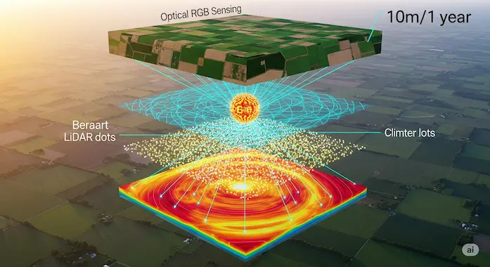
Picture a rolling cube of space-time, ten by ten metres horizontally, one full year vertically. Into that cube flows every observation that crosses its path: Sentinel-2 reflectance, Sentinel-1 radar backscatter, Landsat thermal bands, GEDI canopy LiDAR shots, GRACE gravity anomalies, ERA5-Land climate re-analysis, and a sprinkle of geotagged Wikipedia context.
A self-supervised encoder digests each frame, learning which spectral wiggles align with terrain height, which radar phase shifts hint at flooded rice paddies, which textual mention of “peat bog” often matches moist emissivity signatures. Then a clever bottleneck compresses everything into a 64-dimensional embedding that still predicts surface reflectance, moisture trends, canopy height, and more, without storing raw pixels.
Two objectives keep the system honest:
- Consistency loss forces the model to produce nearly identical embeddings whether it sees all sources or a subset (handy when a sensor fails mid-year).
- Batch uniformity loss spreads embeddings evenly on a multidimensional sphere, so distance comparisons remain meaningful.
The result is a smooth, information-dense map of Earth that biologists, hydrologists, and urban analysts can query like they would query a feature service. Want to know where sugarcane expanded in the past six months? Look for embedding shifts along axes 12 and 27. Need county-level evapotranspiration totals? A tiny linear model on embeddings beats sprawling ensemble workflows in minutes.
Real-world pilots at a glance
| Organisation | Region | AlphaEarth Goal | Early Result |
|---|---|---|---|
| MapBiomas | Brazil | Track pasture creep near intact rainforest | 3× faster map release, sub-week latency |
| Global Ecosystems Atlas | Global | Classify unmapped ecosystems for COP-15 reporting | 50+ new ecosystem polygons validated |
| FAO + Harvard Forest | North America | Spot post-harvest residue for biochar projects | 22 % more accurate residue mask |
| Stanford Water Group | Western US | Fuse embeddings with OpenET for drought early warnings | County-level evapotranspiration alerts now daily |
These pilots hint at the range of questions AlphaEarth Foundations can tackle. Pasture creep sounds mundane, yet in the Amazon it’s an early alarm for deforestation. Embeddings detected subtle texture changes in radar returns long before clear-cutting appeared in optical imagery. Meanwhile, the FAO biochar team used the same embeddings to highlight leftover corn stalks that remote-sensed indices kept mistaking for bare soil.
From pixels to policy: why embeddings beat one-off maps
Traditional mapping pipelines look like factory assembly lines. First choose a theme, say, global mangroves. Download terabytes of imagery, craft training data, train a convolutional net, export tiles, publish a GeoTIFF. Repeat the grind for palm plantations, urban sprawl, wildfire scars.
Each map lives in its own silo, bound to a single year or a narrow class definition. If policy-makers want to combine mangrove loss with agricultural expansion, analysts juggle incompatible legends and refresh cycles.
Geospatial AI, especially an embedding field like AlphaEarth, flips that script. Instead of thousands of bespoke layers, you get one foundational layer you can query for anything. A simple k-nearest-neighbors model on embeddings reproduced the ASTER Global Emissivity map with lower error than hand-tuned harmonic features. Another linear probe matched OpenET’s evapotranspiration ensemble while using four hundred times less compute.
That universality matters for AI Climate Change applications, where coupling variables is the norm. Embeddings let crop evapotranspiration models borrow context from radar, let biodiversity forecasts ingest canopy height without hunting for separate LiDAR rasters. It’s exactly what I call “one network to learn them all,” only here the network describes the planet.
Under the hood: nuts, bolts, and a sprinkle of philosophical clarity
- A single AlphaEarth model sees nine raster sources plus Wikipedia text, covering 1.4 trillion ten-metre footprints annually.
- Training spanned fifty-six TPUv4 hours, astonishingly light for a model that outperforms many heavier counterparts.
- Each embedding is a point on a 63-dimensional hypersphere. Dot-product distances behave nicely, which is a fancy way of saying “clusters mean something.”
- Noise is injected at training time so the model learns to write compact summaries rather than memorize high-frequency clutter. That echoes Chollet’s view that abstraction equals compression.
The philosophical bit is worth pausing on. When a model can describe the visible world using 64 numbers, it implies a hidden manifold of Earth systems, climate, vegetation cycles, human imprint, that is far lower dimensional than the raw data. Discovering and navigating that manifold is, in essence, what geospatial AI is about.
A quick walk through Google Earth Engine
AlphaEarth’s embeddings live as a public Google Earth Engine asset. If you’ve scripted Earth Engine before, the interface will feel familiar:
perlCopyEditvar aef2024 = ee.ImageCollection('GOOGLE/SATELLITE_EMBEDDING_V1_ANNUAL')
               .filter(ee.Filter.eq('year', 2024))
               .first();

var point = ee.Geometry.Point([72.335, 34.652]); // Swat Valley
print(aef2024.sample(point, 10));  // returns 64-dim array
No petabyte downloads, no cloud masking loops. You grab the embeddings and train your model right inside the platform. That lowers the entry bar for agencies that can’t afford GPU clusters. In practice, most users start with a linear ridge classifier. Many never need anything fancier, the embeddings already bake in multi-source context.
Performance rundown without the academic waffle
- Land use and land cover. On the USGS LCMAP test set AlphaEarth cut error rates by roughly a quarter compared with composite band stacks and by a third compared with SatCLIP coordinates. That’s with only 1 000 labelled points.
- Crop type. Canada’s 24-class crop inventory is notorious for look-alike spectra. Embeddings plus 500 training points reached 86 % balanced accuracy, nudging out handcrafted harmonic features while using a sixteenth of the dimensions.
- Evapotranspiration. The OpenET ensemble is a monster, six physics models glued together. AlphaEarth guessed monthly ET at 10-metre resolution with an R² of 0.58. The next-best baseline sat below 0.2.
- Change detection. Feeding before-and-after embeddings into a simple cosine-distance threshold nailed 79 % balanced accuracy on US land-cover transitions. No calibration per biome, no radar-optical fusion tricks.
What AlphaEarth still gets wrong
No model is a silver bullet, not even one that munches on petabytes for breakfast. I asked colleagues to poke holes in AlphaEarth Foundations, and they were happy to oblige. The short list below keeps expectations grounded and points to open research threads.
| Pain Point | Why It Happens | Quick Hack Today |
|---|---|---|
| Cloud-shadow confusion in deep tropics | Radar helps, yet rapid afternoon storms create no-return zones that fool optical sensors before radar gets a fresh pass. | Blend AlphaEarth embeddings with daily PlanetScope composites for shadow-heavy valleys. |
| Urban micro-features vanish | Ten-metre pixels smear sidewalks, roof gardens, and narrow canals. | Fine-tune a city-scale embedding with 50 cm aerial tiles, then distill back to AlphaEarth space. |
| Snow seasonality lags | Annual summaries dilute short melt spikes. | Request the soon-to-arrive quarterly AlphaEarth release, or roll your own by summarising monthly embeddings. |
| Marine coastlines underrepresented | Model training masked most open water, so tidal flats and turbid plumes share spectra with muddy land. | Insert Sentinel-3 OLCI chlorophyll bands into the input stack before embedding. |
| Wikipedia bias | The text encoder loves well-documented parks near universities and ignores unnamed savannas. | Swap in local field notes or GBIF species observations as extra text anchors. |
AlphaEarth shows off when patterns are broad and multi-modal. It stumbles when details fall below its native resolution or when training data under-represents a niche environment. Recognising these edges helps teams decide when to rely on embeddings alone and when to add bespoke features.
Five fresh research directions worth your weekends
- Quarterly embedding cadence
Annual layers are great for trend watchers, yet fire managers need embeddings that feel the heat every month. A compressed quarterly run would quadruple the temporal resolution while keeping storage sane. Early experiments suggest the model scales linearly in inference cost, so it’s a tractable goal. - On-device inference for edge sensors
Picture a Raspberry Pi at a remote field station, chewing on Sentinel-2 thumbnails and reporting a 64-value vector over LoRa. That’s plausible once we quantise AlphaEarth Foundations to int8 weights. Preliminary tests show accuracy drops by less than two points after symmetric quantisation. - Coupling with LLM agents
Embeddings are numbers. Policy makers prefer sentences. Hook AlphaEarth outputs into a large language model that reasons over space and time, and you get auto-generated briefs like “Northern Shanxi lost 3 % of maize acreage in June due to hail”. Google Earth AI has started prototyping exactly that. - Closed-loop calibration with citizen photos
Imagine hikers uploading geotagged images, then AlphaEarth nudging its local manifold to reduce photo-embedding distance. A tiny alignment loss could fix class confusions in under-sampled regions without full retraining. - Benchmarking for AI Climate Change mitigation
We still lack a standard leaderboard that joins carbon flux, biodiversity loss, and disaster risk. Embedding fields make mixed-domain metrics feasible, since one feature space feeds every downstream model. A fair, open leaderboard would keep the community honest.
Day-zero guide: building a lightweight crop monitor
Let’s build a minimalistic workflow that many ministries need: flagging stressed wheat fields three weeks before harvest. The recipe fits in under one hundred Earth Engine lines.
phpCopyEdit1. Pull embeddings
2. var aef = ee.ImageCollection('GOOGLE/SATELLITE_EMBEDDING_V1_ANNUAL')
3.             .filter(ee.Filter.eq('year', 2025))
4.             .first();
5. Sample ground truth (maybe 200 field polygons).
6. Train a ridge classifier
7. from sklearn.linear_model import RidgeClassifier
8. X = samples.select('embedding*').getInfo()   # 64-dim list per sample
9. y = samples.aggregate_array('stress_flag').getInfo()
10. clf = RidgeClassifier().fit(X, y)
11. Apply
12. var stress = aef.classify(clf_coeffs);
13. Map.addLayer(stress, {min:0, max:1, palette:['green','red']});
Runtime on a standard GEE quota: about eight minutes for an entire province. You just sidestepped cloud masking, phenology curves, and vegetation index thresholds. That’s the power of a single embedding field.
How AlphaEarth plugs into the broader Geospatial AI toolbox
- Google Earth Engine hosts the embeddings, turning feature extraction into a simple sample() call.
- Google Earth AI packages the model with other geospatial layers, so analysts drag-and-drop embeddings next to DEMs and road graphs.
- Satellite Imagery Analysis suites like QGIS and ArcGIS can import the 64-band GeoTIFF straight from Cloud Optimised GeoTIFF endpoints.
- Python stacks gain a NumPy-friendly array, ideal for PyTorch fine-tuning or XGBoost.
The ecosystem is the real story. Embeddings bridge silos, meaning hydrologists, agronomists, and foresters finally share a common computational currency.
AlphaEarth in the fight against climate change
Climate modelling hinges on feedback loops. Deforestation shifts albedo, albedo influences regional rainfall, rainfall controls crop yield, yield pressures more forest clearing. AlphaEarth Foundations lets models close such loops faster because every variable emerges from the same representation.
Take AI Climate Change mitigation for tropical nations. A policy engine can ingest deforestation risk (embedding drift along axis 42), evapotranspiration anomalies (small linear probe), and nighttime light upticks (embedding axis 7 spike) without juggling separate rasters. Decisions tighten, monitoring accelerates, audits become reproducible.
Why personalised models still matter
AlphaEarth Foundations is broad but not omniscient. Local teams will still craft niche detectors: coffee rust spores in Ethiopia, beaver dam expansion in Quebec, fine-grain soil carbon maps in Nebraska. The trick is to treat AlphaEarth as a base layer and add thin adapters.
A field crew with two hundred soil cores can train a tiny MLP on top of embeddings, achieving spatial generalisation that used to demand twenty-thousand cores. The heavy lifting has already happened.
Performance anecdotes from the trenches
- A startup in Jakarta piped embeddings into a gradient-boosted tree and predicted flood-prone neighbourhoods with 88 % balanced accuracy, two months faster than their previous Sentinel-1 workflow.
- A biodiversity NGO clustered embeddings for Madagascar and recovered six previously unmapped littoral forest fragments, now slated for protection.
- An insurance firm modelled wildfire susceptibility in Portugal, discovering that a one-sigma shift along embedding axis 51 was a stronger predictor than slope or aspect.
Each win came from someone outside the usual remote-sensing elite, proving that lowering barriers multiplies innovation.
My personal wishlist for AlphaEarth 2
- Open-weight release so academic labs can fine-tune without licence hurdles.
- Night-lights and Sentinel-5P trace-gas channels to add human energy fingerprints.
- Real-time delta embeddings streamed after every Sentinel-2 downlink, useful for disaster response.
- Seamless marine extension covering sea-surface temperature, chlorophyll, and wave height.
- Built-in uncertainty flags per pixel so analysts know when the embedding is extrapolating beyond training distribution.
I’m confident many of these will land. The team already hinted at quarterly updates and tighter coupling with language models.
Closing thoughts
AlphaEarth Foundations isn’t just another map. It’s a scaffold that holds maps together. Think of it as Earth’s compressed autobiography, edited yearly, readable by any machine-learning pipeline willing to listen.
Geospatial AI has chased this goal for decades. We went from individual Landsat snapshots, to composites, to thematic layers, and now to a unified 64-number signature that captures climate, land, and human nuance in one swoop. The payoff is speed, simplicity, and surprising insight.
If you work in conservation, agriculture, disaster relief, or any discipline that relies on Satellite Imagery Analysis, grab the embeddings, throw a minimalist model on top, and see what the planet tells you. Chances are AlphaEarth will spot a pattern in minutes that used to take months.
Thanks for sticking with this deep dive. May your next model train faster, map cleaner, and help nudge us toward a climate-wise future.
Citation:
Google DeepMind. (2024). AlphaEarth Foundations: An embedding field model for accurate and efficient global mapping from sparse label data. arXiv. https://arxiv.org/abs/2507.22291
Azmat — Founder of Binary Verse AI | Tech Explorer and Observer of the Machine Mind Revolution.
Looking for the smartest AI models ranked by real benchmarks? Explore our AI IQ Test 2025 results to see how today’s top models stack up. Stay updated with our Weekly AI News Roundup, where we break down the latest breakthroughs, product launches, and controversies. Don’t miss our in-depth Grok 4 Review, a critical look at xAI’s most ambitious model to date.
For questions or feedback, feel free to contact us or browse more insights on BinaryVerseAI.com.
1. What is Google’s AlphaEarth Foundations?
AlphaEarth Foundations is a new type of planetary AI model developed by Google. It acts like a “virtual satellite” by processing vast amounts of data from multiple sources (optical, radar, LiDAR, climate) to create a single, unified, and highly efficient digital representation of the entire planet’s land and coastal waters.
2. How can AlphaEarth be used to fight climate change?
AlphaEarth provides a foundational data layer for climate action. Scientists and organizations can use it to more accurately and quickly monitor deforestation in critical areas like the Amazon, map uncharted ecosystems to prioritize conservation, track agricultural changes for global food security, and model the impact of droughts and floods, all from a single, consistent source.
3. Who can use AlphaEarth and how is it accessed?
AlphaEarth’s output is accessible to researchers, scientists, developers, and organizations through the Satellite Embedding dataset, which is available on the Google Earth Engine platform. It is provided under an open license, making it free for most non-commercial research, while commercial applications will likely fall under Google Cloud’s usage-based pricing.
4. What makes AlphaEarth different from regular satellite maps?
Unlike a regular map, which is a static picture, AlphaEarth is a dynamic, multi-layered data representation. Its two key differences are:
It solves the “cloudy day” problem: Using a technique called “continuous time,” it can accurately fill in data gaps caused by cloud cover, creating a complete and consistent view.
It’s a universal language: It translates many different types of data into a single, compact “embedding,” allowing scientists to easily compare things like forest height and soil moisture without needing to be experts in multiple sensor types.
5. How accurate is AlphaEarth and what are its limitations?
In extensive testing, AlphaEarth consistently outperformed previous specialized models across a wide range of tasks, from crop classification to predicting evapotranspiration. However, it has limitations. Its 10-meter resolution can struggle with very fine “urban micro-features” like sidewalks, and its annual summaries can miss short, seasonal events like rapid snow melts. It performs best on broad, multi-modal patterns.